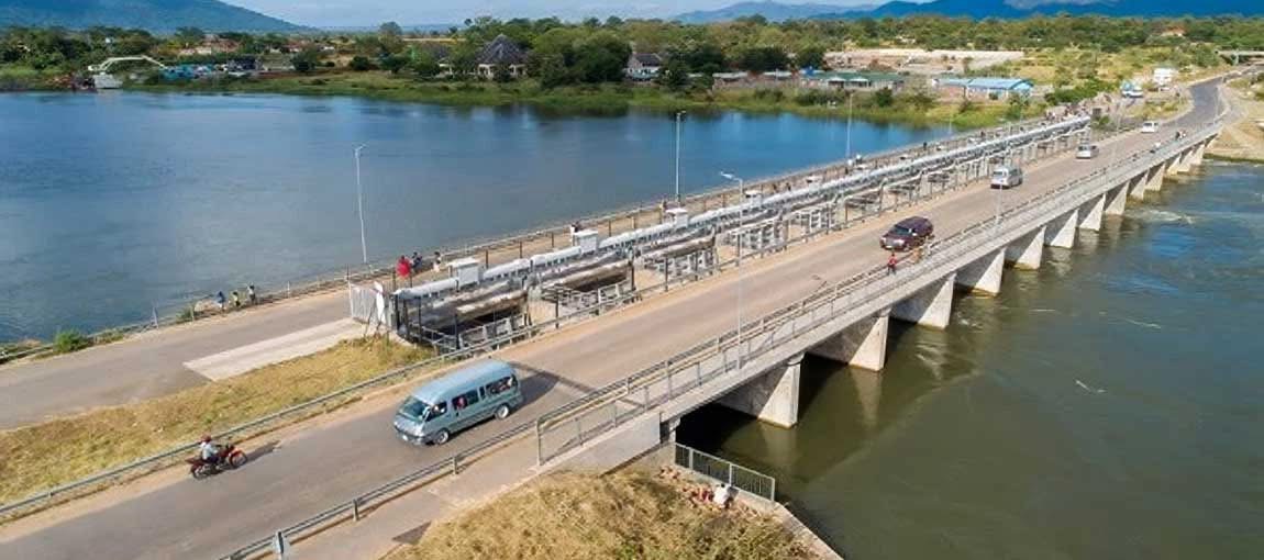
Kamuzu Barrage at Liwonde has been opened to prevent Lake Malawi from swelling further
* In the Shire River, water levels are slightly rising but have not yet reached a level where flooding can occur
* As National Water Resources Authority announces that water level in Lake Malawi has risen at its highest point in years
* The lake stands at 476.01 meters above sea level, which is 0.46 meters higher than last year, same period
By Duncan Mlanjira
The Department of Water Resources indicates that water levels in most of the rivers across the country, especially along the lake shore areas, are increasing, which might result in riverine flooding.

Advertisement
A statement from Henrie Njoloma, Secretary for Department of Water Development in the Ministry of Agriculture, Irrigation & Water Development, says in the Shire River, water levels are slightly rising but have not yet reached a level where flooding can occur.
“The public is advised to be cautious when passing along rivers because there is a high likelihood of flooding due to current trend in water levels,” alerts Njoloma. “The Ministry will continue updating the public on the water levels in rivers across the country.”
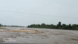
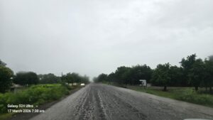
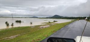
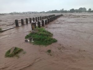
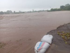
Situation on the ground as captured by Malawi Weather Chasers
Meanwhile, a statement from the National Water Resources Authority (NWRA) announces that water level in Lake Malawi has risen at its highest point in years, indicating that the lake stands at 476.01 meters above sea level (masl), which is 0.46 masl higher than last year under the same period.
The water level could reach 476.4 masl by May, 2026 and to prevent the lake from swelling further, the NWRA says it has opened the Kamuzu Barrage at Liwonde which is now releasing about one million litres of water per second into downstream of the Shire River in order to protect both upstream and downstream communities.
The NWRA says the rise has been caused by heavy rainfall across Central and Northern regions of Malawi and in parts of Tanzania on the eastern side of the lake.

East of Lake Malawi
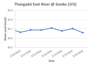
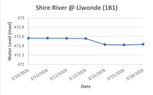
According to the Department of Water Resources, the current trend of water levels in major rivers around the country between March 10-16, 2026 — as observed in some of the primary hydrological stations — is as follows:
1. Shire River @ Liwonde (1B1) — water levels have been stable with a slight decrease from 472.56 masl to 472.43 masl;
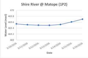
2. Shire River @ Matope (1P2) — water levels are slightly in upward trajectory, rising from 469.54 masl to 469.7 masl;
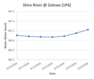
3. Shire River @ Zalewa (1P6) — levels are slightly stable but in upward trajectory from 387 masl to 387.1 masl;
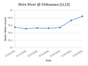
4. Shire River @ Chikwawa (1L12) — levels are in increasing trajectory from 78.54 masl to 78.84 masl;
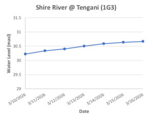
5. Shire River @ Tengani (1G3) — levels have been gradually increasing, from 30.2 masl to 30.66 masl;
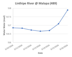
6. Linthipe River @ Malapa (4B9) — levels have risen significantly in the last 48 hours from Monday from 516.69 masl to 517.89 masl;
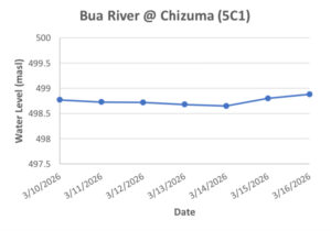
7. Bua River @ Chizuma (5C1) — levels have been relatively stable, slightly rising from 498.77 masl to 498.8 masl;
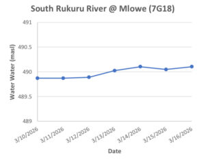
8. South Rukuru @ Mlowe (7G18) — levels have been relatively stable, almost around 490 masl;
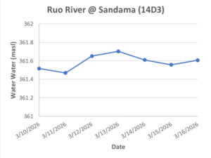
9. Ruo River @ Sandama (14D3) — levels have been fluctuating, but are relatively stable, rising slightly from 361.52 masl to 361.61 masl;
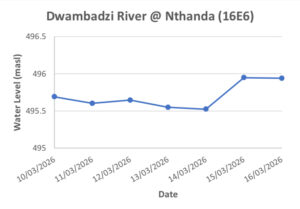
10. Dwambadzi River @ Nthanda (16E6) — levels were stable but have risen in the last 48 hours of Monday from 495.52 masl to 495.93 masl;
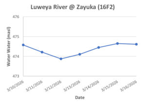
11. Luweya River @ Zayuka (16F2) — levels were in downward trajectory until 12 March 2026, and since then the water levels have been in upward trajectory. The current water level is 474.6 masl;
12. Thangadzi East River @ Gooke (1F2) — levels have been fluctuating but in stable trajectory almost around 85.68 masl;