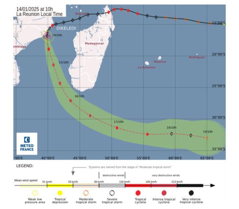
Possible track of tropical cyclone Dikeledi (Courtesy of La Reunion Regional Climate Centre)
* But from today, it is expected to indirectly enhance cloudy conditions with a pick in rainfall activities over some areas which will be heavy at times
* Its centre remains in the Mozambique Channel, near the town of Angoche in Nampula Province at a distance of about 460km from Malawi
By Duncan Mlanjira, Maravi Express & Petro Mkandawire, MANA
In its update of Cyclone Dikeledi on the Indian Ocean, the Department of Climate Change & Meteorological Services (DCCMS) reports that its likelihood of reaching Malawi is very remote — but from today, it is expected to indirectly enhance cloudy conditions with a pick in rainfall activities over some areas, which will be heavy at times.

Advertisement
DCCMS adds that the centre of Cyclone Dikeledi remains in the Mozambique Channel, near the town of Angoche in Nampula Province at a distance of about 460km from Malawi.
“The Cyclone has slightly weakened with its centre pressure now at 990hPa,” says the update. “The cyclone is gradually moving south westwards at a speed of 13km/hr.
“Cyclone Dikeledi is expected to re-intensify over time and is likely to reach the stage of an intense tropical cyclone by tomorrow,” says DCCMS, which is continuing to monitor the cyclones movement, whose next update will be issued tomorrow, January 15.
Meanwhile, the DCCMS has disclosed that from today till January 19, the country will experience an increase in rainfall, windy and cloudy conditions due to the influence of Cyclone Dikeledi.
In an interview with Malawi News Agency (MANA) yesterday, DCCMS’ head of public weather and aviation services, Yobu Kachiwanda said there is a chance of rough conditions over Lake Malawi, Lake Chirwa and other water bodies, followed by a low-pressure system that will be located near Beira in Mozambique starting from Thursday, January 16.

Yobu Kachiwanda
He added that the unstable air mass will influence the weather as such people should expect isolated thunderstorms and rain over the north and lakeshores.
“Torrential rains can weaken structures as such people should pay attention and inspect walls,” he said. “When thunderstorms are within our facilities, let us stay indoors, avoid open fields, tall trees, metal objects and avoid crossing flooded or fast-moving water.”
During the past week, many areas experienced predominantly cloudy skies, accompanied by scattered thunderstorms and heavy rain that led to destructive events in certain areas — including roofs blowing off at Usisya in Nkhata Bay on Friday and a notable 24-hour rainfall of 114mm was measured in Mayaka, Zomba on January 9.
Executive Director for Managing Rainwater Association of Malawi (MRAM), Edmond Kwasula said the association was on the ground ensuring that drainages and waterways are free of obstructions.
He hailed the weekly weather statement provided by the DCCMS, saying the weather information helps to keep the public updated on weather issues.
“Weather information comes at the right times,” Kwasula said. “We will make sure that we are working hand in hand with the department to raise more awareness on the impending cyclone.”
He said MRAM will ensure that measures are put in place to minimise Dikeledi effects, if there will be any.


Advertisement