Maps of some of the rainfall recorded last week
* Expect occasional thunderstorms accompanied by rain of varying intensity to continue in many areas until Thursday, January 9
* Due to the Inter-Tropical Convergence Zone and pulses of Congo air mass
By Duncan Mlanjira
In its summary of the weather in this week, the Department of Climate Change & Meteorological Services (DCCMS) alerts that public to expect occasional thunderstorms accompanied by rain of varying intensity to continue in many areas until Thursday, January 9, due to the Inter-Tropical Convergence Zone and pulses of Congo air mass.

Advertisement
“Be aware of a high risk of flash floods, especially in lakeshore and northern areas,” says the report issued this evening. ‘Rainfall is expected to lessen in Malawi starting Friday, January 10th to Sunday, January 12th, 2025.”
On safety precautions during flash floods, the public is being asked to avoid being outside and during thunderstorms to seeking shelter in a safe building as well as avoiding open areas, tall trees and metal structures.
On wet conditions, “be watchful of overly wet structures, such as houses, walls and toilets that could collapse at any time.

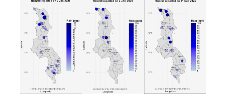
On the weather in the past week, DCCMS says rainfall increased across many areas, with several areas experiencing significant precipitation.
Specifically: Northern areas (Kameme in Chitipa) received 62.4mm of rainfall on January 2 and on the Lakeshore areas (Vinthukutu in Karonga) recorded 102.6mm on January 3, and Nkhunga in Nkhotakota received 95.4mm on January 2.
Southern highlands (Bvumbwe in Thyolo) reported 53.8mm of rainfall on January 3 while the Central areas (Chamama RTC in Kasungu) had 63.0mm of rainfall on January 5.
The Shire Valley (Supuni in Chikwawa) recorded 33.2mm of rainfall on January 4.
