US government-funded program BuckEye successfully maps 99% of Malawi
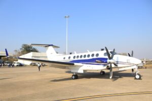
* The experts used advanced aircraft, equipped with state of the art geospatial surveying technology * The imagery the BuckEye program compiled will be passed on in its entirety to DoDMA * For use in areas such as hazard assessment, improving early warning systems, optimizing resource management and informing recovery planning By Elia Chibwe, MANA A US-funded programme, Army Geospatial Center high resolution 3 dimensional (HR3D), also known as BuckEye in Malawi — which deployed a Beech King Air…